
101 Metropolises
November 2011 – A few years ago, the Metropolitan World Atlas was published, according to author Arjen van Susteren, “the first atlas in the world based on urban agglomerations”. The Atlas has since become a global hit, and we interviewed its proud creator. “Metropolises have definitively broken free of their landscapes.” The interview about the Atlas is part of a years-long Favas.net investigation into metropolises worldwide, including an Asian series featuring Jakarta, Lahore, Mumbai, and Tokyo.
Selection
Choosing the world’s most important metropolises isn’t easy, as urban planner Arjen van Susteren quickly realized. Especially if you’ve set yourself the goal of having exactly 101. One hundred plus one makes it possible to compare each metropolis with exactly one hundred others! Population size is, of course, an important factor, but Arjen’s selection criteria primarily focused on connectivity, due to its importance in the global economy. He defines a metropolis primarily as an urban area that is globally connected to other urban centres. Such a definition makes it even more relevant to compile lists for comparing metropolises, for example: the 50 largest cities in the world, the 25 largest seaports, the 30 largest airports, and the 30 largest telecom hubs. Based on the criterion of international connection, 89 metropolitan areas could be identified.
To arrive at a list of 101, 12 metropolises (101-89) had to be selected. “That’s arbitrary, of course”, the author explains, “but you have to do something. Stockholm couldn’t be left out, and neither could Baghdad, a city where our civilization began. I also couldn’t bring myself to leave Berlin out, so I selected several other cities, such as Vancouver and Melbourne.”
Map and key data
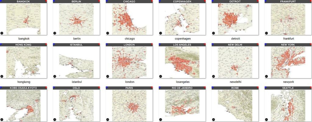
Compiling the Metropolitan World Atlas was indeed painstaking work. The result is a substantial, useful, and above all beautifully designed book, the first of its kind, according to the author. The Atlas, which is now even being promoted on Japanese websites, exists in four versions, each with its own cover; the book can be ordered with New York, London, Moscow, or Tokyo on the cover, if desired (for sure, Favas.net acquired the one with the Tokyo cover!).
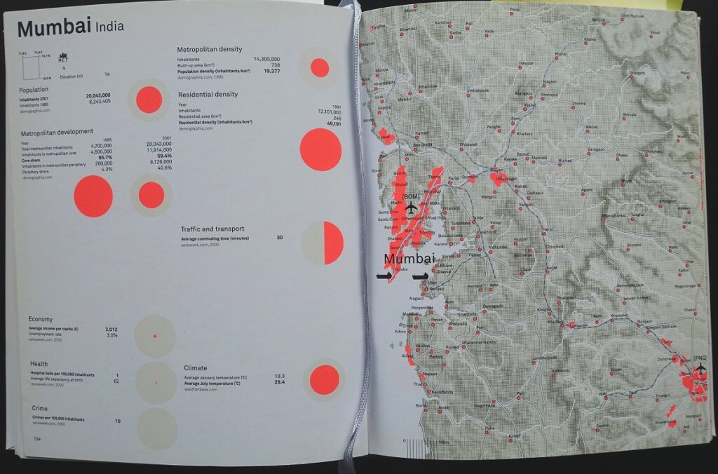
A map has been created for all the metropolises in the Atlas, at a scale of 1:750,000, and all key data, where available, has been compiled. So everyone can see that Denver, with its barely two million inhabitants, is many times larger in area than Mumbai, India, which has twenty million inhabitants. The gross per capita income in Washington is 22,000 euros, compared to 4,500 in Shanghai and less than a thousand in Bangalore. “All of this is an estimate”, Arjen emphasizes, “because if one thing has become clear to me, it’s that statistics are unreliable anyway, especially in countries outside Europe and North America. Unemployment in the Third World, for example, is a relative concept, because in many countries you simply can’t afford to do nothing. But even about population size, little is sometimes known. I lived in Mexico City for a while, and city officials there told me that there’s a difference of five million between the highest and lowest estimates of the population.”
Nevertheless, he relied on official data in compiling his book. “That’s simply all you have. And despite the inadequacy of the data, the Atlas provides a great deal of insight into the differences, and similarities, of the world’s largest metropolises.”
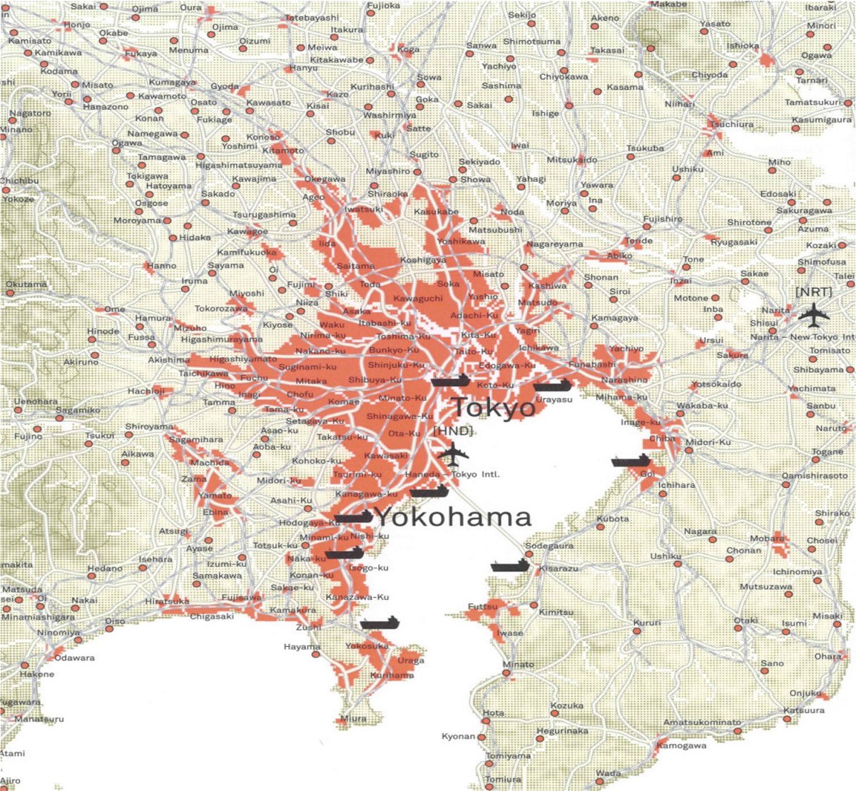
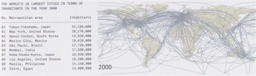
The Asian efficiency of air travel, for example, becomes clear. Phoenix, Arizona, has nine airports for a metropolitan population of 2.9 million. On the other side of the world, in Tokyo, a staggering 33.2 million people live, making do with just two airports. Arjen concludes that “in America, aircraft are much lighter than in Japan, or that many smaller, frequently flying aircraft are used.”
This is a prime example of the key characteristics revealed in the Atlas. The footprint in America differs fundamentally from that in Asia. The global top thirty airports include almost exclusively American airports, and a handful of European ones, including Schiphol, but not a single Asian airport (at least to the situation around 2000). Yet, the volume of cargo per aircraft in Asia is much higher than in the rest of the world. Only one conclusion can be drawn: airports in metropolitan areas like Tokyo are used much more intensively and efficiently than in the US. And this applies not only to those airports, but also to Asian metropolises.
Overestimating American Cities
Arjen defines a metropolis not only by the classic criterion of size, but also by the extent to which a metropolis is internationally and intercontinentally connected. Initially, water was the only way to connect metropolises. In the last hundred years, telecommunications and aviation have been added, with which metropolises have “definitively detached themselves from their landscape.”
The question is whether the aviation criterion doesn’t lead to an overestimation of the international position of American cities. After all, a large part of air travel in America involves domestic travel. It is precisely these journeys that are increasingly made by high-speed train in Europe and Japan.
An underestimation is also threatened because, according to Arjen, a ‘mainport’ should be defined as a metropolis that houses both an international airport and shipping port, as well as an international communications hub. However, an international railway hub is missing from this list. And it is precisely these types of hubs that are very important in Europe and Japan.
The author’s response is pragmatic and substantive. “One solution would be to filter domestic air traffic in America from the statistics. But that runs up against pragmatic limits; it’s very difficult and requires a lot of work.” Substantively, he argues that train services within Europe and Japan are not related to intercontinental relations.
We don’t think that last point is a strong argument. Especially for Europe, international relations within the continent itself are often at least as important as those between Europe and America.
Update needed

For example Hong Kong and the Pearl Delta. During the last 25 year this delta has been urbanized substantially (area red circle inserted by Favas.net). Shenzhen on the Metropolitan World Atlas is still a small place. Indeed. it’s striking that even barely six years after the Atlas’s publication, the information about the rapidly developing Asian cities is outdated. The rapid growth of these metropolises demands an update. So, to be continued…
Arjen van Susteren, Metropolitan Word Atlas. 010 Publishers, Rotterdam, 2005.
Note: The data cited in the interview is based on the Atlas’ sources around the year 2000.

This text is an adaptation and translation of the interview by Rob van der Bijl and Bert Bukman, which previously appeared in the Dutch professional journal for landscape architecture and urban planning, Blauwe Kamer (2-2006).
See also at Favas.net:
Arjen van Susteren & Rob van der Bijl on ‘Sex and the City’ (at the ‘Red Light Realm’ page, November 2011)
An introduction on the series City Maps: Mumbai (India)
Text: Favas.net
Research & editing: Favas.net
Map images: Metropolitan Word Atlas (partly edited by Favas.net)
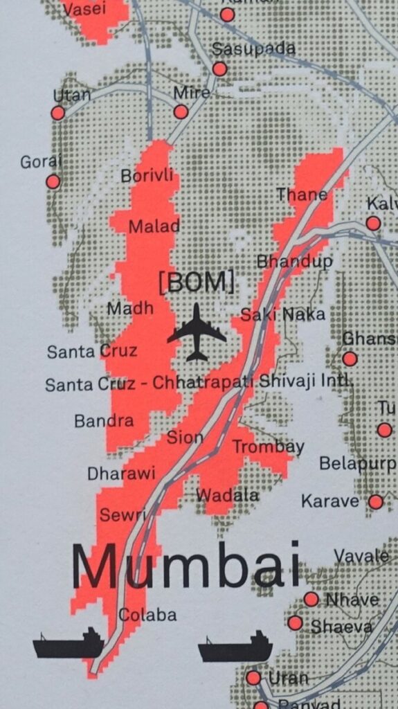
Detail from the original map from Metropolitan Word Atlas.